My favourite place at the coast is Conil de la Frontera, near Cádiz. It is a beautiful old village by the sea with a huge beach and a front full of bars and restaurants. The big attraction for me is the land to the north of Conil. The cliffs here rise gradually and form isolated bays which are sometimes empty of holidaymakers. The cliffs are being constantly eroded and so the concrete stairs built by the ayuntamiento of Conil are often washed away by the winter storms. But you can nearly always scramble down to reach the sand.
I love to snorkel and the water here can sometimes be clear up to three or four meters, or muddy, depending on the winds and currents. You have probably gathered by now I have a passing interest in geology. The cliffs and land around Conil are composed of fossilized seashells. They are from the early Pliocene period about 5.3 million years ago and are so abundant that the five meter high cliffs are almost entirely composed of these well preserved shells.
When I came to Spain I was running on a shoestring budget. My rent was the only income I had, along with just over a thousand pounds savings, earned from working all the overtime could get whilst I was still employed. When the exchange rate dropped I was plunged into a crisis. Often the money would run out before the next rent arrived. I was living on borrowed time. To go back to England at 63 years old and try to find work was something I did not want to think about.
To escape my worries I decided to go to Conil and go down the coast to the southernmost point of Europe, Tarifa, ten miles from North Africa; Another continent. If I had to go back I would take some memories with me.
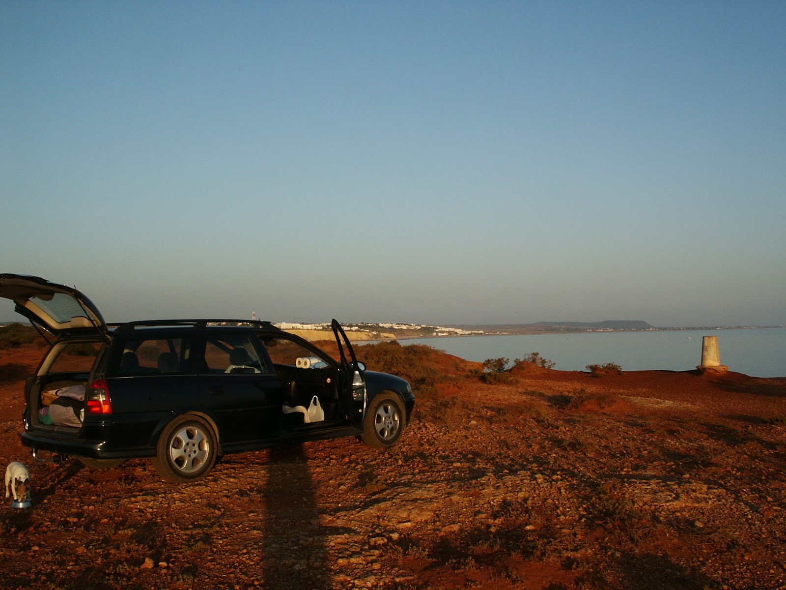
Parking in Conil is difficult, but not impossible. It is far easier (And cheaper.) to park on the cliffs by the lighthouse. It you drive into town and buy a pollo asado with patatas at the take away shop on the edge of the pueblo, then return the two km. to the coast you can eat your supper under the stars and listen to the waves smoothing the sand below the cliffs. If you have brought a cardboard box full of Cruzcampo beer, then you have it made. I had got this down to a fine art.
 Over time, these cliffs became my escape. My haven from the worries and fears that I often had. When I split up with my girlfriend in Antequera, I came here. After I had to have the vet kill my little dog because she had cancer, I came here. When I was sick of the petty power plays and back biting in Olvera, I came here. I could rant at the stars, which coldly ignored me, whilst I worked out what to do next.

The little harbour at Conil is full of private boats and some commercial fishing boats.
None are very big. The real fishing is done from Barbate. Just behind the harbour, in a car park there is a strange sight. I am not sure who finds them. Maybe the fishermen have their nets torn by them and so get somebody to haul them up, but there are well over a hundred old anchors neatly stacked in lines. They are nearly all the same, which suggests that they are from the same period. Maybe they were all lost in one battle. The battle of Trafalgar took place just down the coast, so maybe they have been brought up from the seabed around there. Barbate has a similar collection in its harbour.

I have few photos of Barbate but it is the centre of the tuna fishing industry. The tuna migrate from the Atlantic to the Mediterranean every year in May and June and the fishermen use a method of caching them which dates back to the Phoenicians. They use long deep nets to trap the tuna and bring them to the surface to be pulled out and killed. This yearly event is called the Alamdraba.
During the last few years the catch has been restricted by treaties with Morocco and the indignant Spanish fishermen have had to be turned back by the maritime Spanish police to avoid incidents at sea. There is big money in the tuna. Japanese fish merchants will pay millions of Euros for fish to sell in Japanese restaurants. 95% of the catch is shipped straight to Japan.
 El Cabo de Trafalgar is a lighthouse and nothing more. The battle is more important than the coastline. In England we don’t pronounce Trafalgar correctly. The correct Spanish pronunciation is Trafalgar with the emphasis on the raf.
The piece of coast between Trafalgar and Tarifa is not developed. When Franco allowed the coasts of Spain to be turned into a holiday resort in order to generate much needed revenue, his advisors in the military asked him to leave this stretch of coast for the armed forces to train on. Zahara de los Atunes is a largely undeveloped town with a splendid beach There are houses to the south side there, but they are for the rich. The coast is rugged here and you must go inland to continue down to Tarifa.

On this trip I had not done my homework and I drove past the ruins of a roman town I would have liked to have seen. Bolonia. Maybe I will go back and see it sometime in the future.
 The route inland took me along a valley which was almost entirely planted with sunflowers. It was also full of wind turbines. This part of southern Spain is famous for its strong winds and this asset is being developed to the full. According to the Diario de Cádiz, one day in 2011 there were strong winds throughout Spain. One by one the conventional power stations were shut down to idling as the wind turbines took up the load. In the end 60% of all Spain’s power was being provided by the turbines alone.

Just before I reached Tarifa I stopped at the huge beach by the side of the road called Playa de la Plata. It seemed a good place to spend an afternoon. As I drove amongst the other parked cars and vans I realized what I had found. This was a community of Wind and Kite surfers. But it was like the 60’s all over again. If you have seen the film Point Break then this was just like the beach surfing community in the film. Their vehicles were something to see. I parked next to a mobile home, which was to say the least, totally awesome man.


Here is the winter side.

This was the usual daytime scene along the beach, with campfires and parties, guitars, singing, drinking and all the things you would expect to have happening amongst the beautiful people.

I am not being sarcastic.
Once, a long time ago, I had long hair. It was The Beatles, Easy Rider and Pop festivals. Then I met my future wife. I forgot all about being born to be free, my wife and I brought up our children, became slaves to the banks and my own ambition and I ended up here on this beach at 63, alone, with money problems.
The people around me had never lost their dream. They will be forever young.
Much later I painted this picture of the beach which was intended to be more of a cartoon than a painting. I put in the Atlas Mountains across the Straights of Gibraltar, which you can barely see from the beach, to add a little more to the picture.
To see all the paintings of artistandalucia click here.

I spent maybe half a day in Tarifa, which was another mistake, because there is quite a lot to see if you plan correctly. There is a fortress, which I missed, and the Guzman Tower, which I photographed but never went in. I seem to remember it was closed that day.

Originally built in 960 on the orders of Cordoban caliph Abd ar-Rahman III, this fortress is named after the Reconquista hero Guzmán El Bueno. In 1294, when threatened with the death of his captured son unless he surrendered the castle to attacking Islamic forces, El Bueno threw down his own dagger for them to use to kill his own son. He must have had some spare sons and daughters because Guzmán’s descendants later became the Duques de Medina Sidonia, one of Spain’s most powerful families. I just can’t help wondering what his betrayed son had to say before he died.
I had touched the most southern point in Europe. I walked out along the causway to the fortress that guards the northen side of the straights between the two continents and photographed the sign on the fortress gates.

That night I went back to the surfers beach.
I ended the day sitting on a Spanish beach watching the fires of the kite surfers, armed with a little knowledge and a couple litres of beer, listening to the dry pages of history and geology come to life in my head. The fossilized seashells at Conil that I mentioned earlier lived in a shallow sea that filled the valley of the Guadalquiver river. As the continent of Africa pushed into the European plate it lifted southern Spain above sea level. But about six hundred thousand years earlier than the seashells at Conil, the straights of Gibralter had been closed by the lifting of the crust. There was a land bridge between Spain and Africa.
This had happened several times before, but this was the last time that the two continents had been joined and the Mediterranean had been isolated from the world’s oceans. Over a period of a hundred thousand years or so the Mediterranean evaporated, leaving salt flats in its shallower parts. Some parts of the Mediterranean are quite deep and they became saline lakes a kilometer or more below the outside world ocean levels. The planet was locked in an ice age at the time and it brought typical arid climate conditions. Sea levels had dropped because of the huge polar ice caps. This is called the Messinian event and it happened 5.33million years ago
Then the ice age ended. Sea levels rose and the world average ocean level rose above the land bridge. The Atlantic Ocean spilled into the empty Mediterranean basin.
There was no great waterfall here. The slope of the seabed is gradual, but nevertheless, the flow must have been huge.
Sitting next to the southernmost point of Europe and looking across the straights I could not help but imagine the sight of that huge cascade into the enormous empty valley to the east. The noise would have been deafening and earthshaking and it probably lasted thousands of years before the Mediterranean equalized with the Atlantic.
 The next day I drove up through the mountains and looked back to see the Atlas mountains of North Africa across the straights.
I didn’t have to go back to England in the end. I had figured out a plan under the stars.
I love to snorkel and the water here can sometimes be clear up to three or four meters, or muddy, depending on the winds and currents. You have probably gathered by now I have a passing interest in geology. The cliffs and land around Conil are composed of fossilized seashells. They are from the early Pliocene period about 5.3 million years ago and are so abundant that the five meter high cliffs are almost entirely composed of these well preserved shells.
When I came to Spain I was running on a shoestring budget. My rent was the only income I had, along with just over a thousand pounds savings, earned from working all the overtime could get whilst I was still employed. When the exchange rate dropped I was plunged into a crisis. Often the money would run out before the next rent arrived. I was living on borrowed time. To go back to England at 63 years old and try to find work was something I did not want to think about.
To escape my worries I decided to go to Conil and go down the coast to the southernmost point of Europe, Tarifa, ten miles from North Africa; Another continent. If I had to go back I would take some memories with me.
Parking in Conil is difficult, but not impossible. It is far easier (And cheaper.) to park on the cliffs by the lighthouse. It you drive into town and buy a pollo asado with patatas at the take away shop on the edge of the pueblo, then return the two km. to the coast you can eat your supper under the stars and listen to the waves smoothing the sand below the cliffs. If you have brought a cardboard box full of Cruzcampo beer, then you have it made. I had got this down to a fine art.

The little harbour at Conil is full of private boats and some commercial fishing boats.
None are very big. The real fishing is done from Barbate. Just behind the harbour, in a car park there is a strange sight. I am not sure who finds them. Maybe the fishermen have their nets torn by them and so get somebody to haul them up, but there are well over a hundred old anchors neatly stacked in lines. They are nearly all the same, which suggests that they are from the same period. Maybe they were all lost in one battle. The battle of Trafalgar took place just down the coast, so maybe they have been brought up from the seabed around there. Barbate has a similar collection in its harbour.

I have few photos of Barbate but it is the centre of the tuna fishing industry. The tuna migrate from the Atlantic to the Mediterranean every year in May and June and the fishermen use a method of caching them which dates back to the Phoenicians. They use long deep nets to trap the tuna and bring them to the surface to be pulled out and killed. This yearly event is called the Alamdraba.
During the last few years the catch has been restricted by treaties with Morocco and the indignant Spanish fishermen have had to be turned back by the maritime Spanish police to avoid incidents at sea. There is big money in the tuna. Japanese fish merchants will pay millions of Euros for fish to sell in Japanese restaurants. 95% of the catch is shipped straight to Japan.
The piece of coast between Trafalgar and Tarifa is not developed. When Franco allowed the coasts of Spain to be turned into a holiday resort in order to generate much needed revenue, his advisors in the military asked him to leave this stretch of coast for the armed forces to train on. Zahara de los Atunes is a largely undeveloped town with a splendid beach There are houses to the south side there, but they are for the rich. The coast is rugged here and you must go inland to continue down to Tarifa.

On this trip I had not done my homework and I drove past the ruins of a roman town I would have liked to have seen. Bolonia. Maybe I will go back and see it sometime in the future.


Just before I reached Tarifa I stopped at the huge beach by the side of the road called Playa de la Plata. It seemed a good place to spend an afternoon. As I drove amongst the other parked cars and vans I realized what I had found. This was a community of Wind and Kite surfers. But it was like the 60’s all over again. If you have seen the film Point Break then this was just like the beach surfing community in the film. Their vehicles were something to see. I parked next to a mobile home, which was to say the least, totally awesome man.


This is the summer side.
Here is the winter side.

This was the usual daytime scene along the beach, with campfires and parties, guitars, singing, drinking and all the things you would expect to have happening amongst the beautiful people.

I am not being sarcastic.
Once, a long time ago, I had long hair. It was The Beatles, Easy Rider and Pop festivals. Then I met my future wife. I forgot all about being born to be free, my wife and I brought up our children, became slaves to the banks and my own ambition and I ended up here on this beach at 63, alone, with money problems.
The people around me had never lost their dream. They will be forever young.
Much later I painted this picture of the beach which was intended to be more of a cartoon than a painting. I put in the Atlas Mountains across the Straights of Gibraltar, which you can barely see from the beach, to add a little more to the picture.
To see all the paintings of artistandalucia click here.

I spent maybe half a day in Tarifa, which was another mistake, because there is quite a lot to see if you plan correctly. There is a fortress, which I missed, and the Guzman Tower, which I photographed but never went in. I seem to remember it was closed that day.

Originally built in 960 on the orders of Cordoban caliph Abd ar-Rahman III, this fortress is named after the Reconquista hero Guzmán El Bueno. In 1294, when threatened with the death of his captured son unless he surrendered the castle to attacking Islamic forces, El Bueno threw down his own dagger for them to use to kill his own son. He must have had some spare sons and daughters because Guzmán’s descendants later became the Duques de Medina Sidonia, one of Spain’s most powerful families. I just can’t help wondering what his betrayed son had to say before he died.
I had touched the most southern point in Europe. I walked out along the causway to the fortress that guards the northen side of the straights between the two continents and photographed the sign on the fortress gates.

That night I went back to the surfers beach.
I ended the day sitting on a Spanish beach watching the fires of the kite surfers, armed with a little knowledge and a couple litres of beer, listening to the dry pages of history and geology come to life in my head. The fossilized seashells at Conil that I mentioned earlier lived in a shallow sea that filled the valley of the Guadalquiver river. As the continent of Africa pushed into the European plate it lifted southern Spain above sea level. But about six hundred thousand years earlier than the seashells at Conil, the straights of Gibralter had been closed by the lifting of the crust. There was a land bridge between Spain and Africa.
This had happened several times before, but this was the last time that the two continents had been joined and the Mediterranean had been isolated from the world’s oceans. Over a period of a hundred thousand years or so the Mediterranean evaporated, leaving salt flats in its shallower parts. Some parts of the Mediterranean are quite deep and they became saline lakes a kilometer or more below the outside world ocean levels. The planet was locked in an ice age at the time and it brought typical arid climate conditions. Sea levels had dropped because of the huge polar ice caps. This is called the Messinian event and it happened 5.33million years ago
Then the ice age ended. Sea levels rose and the world average ocean level rose above the land bridge. The Atlantic Ocean spilled into the empty Mediterranean basin.
There was no great waterfall here. The slope of the seabed is gradual, but nevertheless, the flow must have been huge.
Sitting next to the southernmost point of Europe and looking across the straights I could not help but imagine the sight of that huge cascade into the enormous empty valley to the east. The noise would have been deafening and earthshaking and it probably lasted thousands of years before the Mediterranean equalized with the Atlantic.

I didn’t have to go back to England in the end. I had figured out a plan under the stars.


