Thursday, April 18, 2013

The Escarpment walks


          There are two escarpment walks. Both start at the same place. As you drive into Torre Aláquime from Olvera there is a right hand turn with a bus shelter in front of you. (see photo). Just as you pass the RH turn into the pueblo there is a track that goes straight on. This is the track you take. From this point on both walks you will rise gradually to a high point of 180m (590ft.) higher than where you parked the car. If you choose the short route you will cover 5.7km. If you choose the long route you will cover 8.4 km. At the end of both walks you must walk from the riverside to where you left the car, a distance of half a kilometer winding through the pueblo, but a climb of 50 or so m. (165ft.)
                    The long escarpment walk.

                The short escarpment walk.            
For parking just find a place off the road here where the photo is taken and make sure you are not blocking anybody's entrance. You won’t need boots if it’s dry, but there are patches that are muddy after rain.  The photo shows an arrow going to the left to the radio towers walk. This is the next walk on the blog.
          The walk rises up the hillside until you are walking beneath a cliff of yellow sandstone. The track turns right here and you follow the base of the cliff for two kilometres. The cliff is made up of the broken fossils of seashells. Further to the south-east at Setinil the seashells become more pronounced and identifiable, making dating these sandy rocks easier. They are from the Tertiary period around 200 million years ago.
 
          You will follow the base of the cliffs till you come to an old farmhouse on the right.


                To shorten the walk you must cut across the olive grove to find the other track lower down. From the RH corner of the farm house turn almost 90 degrees right and follow the rows of olive trees which descend down the hillside. If it has been raining it can be very muddy amongst the olive trees so you will need boots.. When you reach the bottom of the embankment you must turn left and follow the 4x4 track which you should be able to see to your front left. This will lead to a concrete road and take you back to the main road into Torre.


           The river in the valley below is the Guadalporcún, which is fed by tributaries in the flat land above Setinil. The gorge at Setinil was cut by of one of the faster flowing tributaries of this river. But here it is slow and quiet. The valley is green with fertile soil brought down over the millenia. Torre Aláquime is on a bend in the river. Torre means tower and Al-Haquim was an overseer who was held in high esteem by the ruling Caliph. He was granted lands around the high tower which he built here on top of the peñon at the bend in the river. A perfect defensive point, covering the river and the track up to Olvera. Torre was supported by the other two watchtowers. One on the Peñon de Pruna and the other just off the Campillos road as you leave Olvera. They were most likley garrisoned with troops from the castle at Olvera, where the village was inside the murellas, or defensive walls.
          In 1327 the Christians took Olvera and the fortress at Torre Aláquime was abandoned, the garrison retreating to Ronda. Six years later the Muslims re-took Torre. At the start of the 15th century the Christians took Torre back as well as Zahara and Muslim rule here was finally ended. Torre and its surrounding area came under the control of the powerful Rivera family. 
 
         Torre Aláquime  is worth a look as part of the walk. Its tower is long gone, but the arch leading to the inner town is still there and there is a garden in what would have been the courtyard below the keep.
The river from Torre 
                                                     The fortifications above Torre.
           It is a sleepy village now, but it has seen war and bloodshed in the past. It was a scene of destruction in 2010 when the river flooded. I painted a view of the river that year when the whole valley was flooded. The sky was stormy and the sun came through in the end, but not before it had changed the course of the river here by filling the old bed with sand and cutting a new channel a hundred meters away from the old one.To see all the paintings on artistandalucia click this link
 
            As a postscript, I did this walk four years ago and again last week. In the spring of 2013 southern Spain had more rain than anytime in the last 60 years. The first corner where the track turns to the right had a tree across the track. Because I have arthritis in one knee I use a bicycle now to cover the walks.

  I had to carry my bicycle around the roots, but further on, the road had collapsed into a hole cut by rainwater and swept down into the valley.


Friday, March 29, 2013

Reloj

I live in the far south of Spain, but from time to time the temperatures drop to the point where snow can fall and icicles can form. From my roof terrace there are three peaks on the horizon that in winter are often white with snow. The first is El Torreon, the highest peak in Cadiz province. The other two are Reloj and Simalcón.


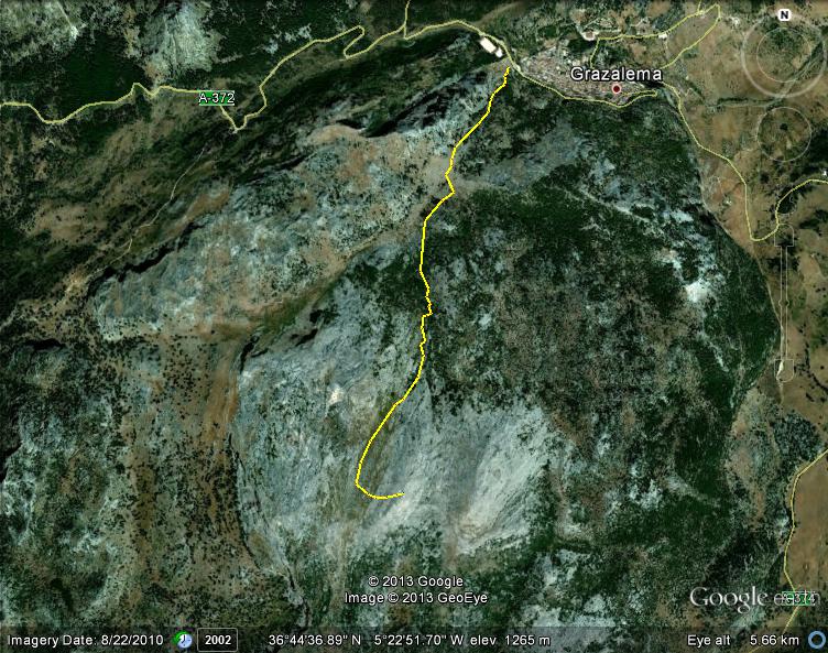
This walk is the ascent of Reloj (The Clock) 6.8km. to the summit and back. Altitude climbed 615m.(2,017ft.)


It is a steep walk and not for the unsure of foot. To reach the summit you will be scrambling, sometimes on all fours. At the end of the climb you will be scaling five metre boulders and huge slabs of white limestone with every chance of a fall. Your mobile will work here, but a broken leg or sprained ankle puts you in a bad situation. The walk is well known and there will always be other walkers, but always come prepared to have to sit for two or three hours whilst help arrives. Warm clothing, water and high protein snacks are a must. So are good boots.

The walk starts at the back of the car park in Grazelema just outside the gates to the Tajo Rodillo camp site. At the top end of the car park is a gate. This takes you over an area of broken rocks to a footpath leading up into a pine forest. The path is clear though rough in places over rocks and tree roots. On your right is the rock face of Penñon Grande, popular with rock climbers. You will climb up to the top of a hill which is clear of trees. You should be at the end of a valley with a flat grassy area in the bottom and a grove of pine trees.

 
This is Llano del Endrinar. The grassy area is fenced off and there may be cows there. Work your way around to the left hand side of the flat area and look for the path going off in a SE direction zig zagging up the up the hillside.

The climb is steep and often rugged, but it is nothing compared with the final part of the climb. When you finally stop climbing and reach the flat part between two hills you must walk along the often invisible path on the left hand slope. I seem to remember a lone sapling by the track just before the path leads off to the left and begins to climb the sloping limestone beds. There are terraces and sometimes steps cut into the rocks. Keep looking for the little cairns left to mark the route. Some obliging gentleman has painted arrows in black paint on the white limestone. These and the cairns mark the route, though often you will be looking around for the next marker. It's not always clear. The summit will be now right above you and is marked with a cairn of rocks.


My little companion was like a mountain goat hopping from boulder to boulder. I was treading more carefully, but we finally made it. Try to pick a clear day. I have done this walk with friends and arrived at the top in cloud. It´s always a pity to climb all day and end up not being able to see anything.

Looking to the north west from the summit of Reloj on the other side of Simalcón is the huge bulk of El Torreón.


Monday, February 25, 2013

Genal valley trip

May 2010
Montejaque, Benaojan, Jimera de Libar, Cortez de la Frontera, Algatocin, Guadalguacin, Algatocin, Benaluria, Benadalid Ronda. 
One of the free Spanish classes  trips took us to the Genal valley. There were two coaches of people who’s classes involved learning English, maths, Spanish and Spanish. The last part of the sentence is not a mistake. There were two classes learning Spanish. One was the English learning Spanish and the other was the Spanish learning Spanish. Many of the 60+ Spanish cannot read or write their own language. They grew up in a time when there were no formal classes or schools for their own language.

When they reached maturity they were in a nightmare world where the military and church suppressed learning. If you were caught reading newspapers to the illiterate during Franco’s time the police would take you away and you would never be seen again.
 Try to find a film called La Voz Dormida. It is in Spanish, but you will understand the plot even if you only have a little Spanish. It portrays the horrors of those times. There is a house here in Olvera with a big cellar where, as the story goes, two hundred men hid. Food was thrown over the walls of the garden by the people of the village. Their waste was taken away at night by the villagers. I can believe it.  
The people who could read and write or simply critical of the regime disappeared. Now in 2013, their relatives are seeking the graves of their grandparents who were killed during the Franco years.
  
The third class, maths, again for the 60+ who could not do simple arithmetic on paper. However, don’t assume that because they cannot write basic arithmetic they are incapable of adding and subtracting in their heads. You will never see a native Spaniard short changed in a shop. They will bring the roof down for such an offence. I have played dominoes and cards with these guys and they are very clever.


However, back to the excursion.
The road to Montejaque leaves the A374 to Ronda and winds down a scary narrow road looking over a huge mound of detrius which has fallen from El Tejar, a huge slab of stratified limestone. It was here that the Spanish decided to build a dam and trap the waters that normally flowed through the the Hundidero cave system. The dam was constructed and everybody waited to it to fill. This is karstic country. Limestone dissolves over the centuries and fissures form, which allow water to find a way to lower levels.   
The dam never filled. The water always found another way out.
Having said that in the floods of 2010 it did fill half way up because the fissures could not get the water away fast enough.
 Benalauria, Algatocin, Benadalid 
These pueblos were once part of a highway for traders and soldiers. The ports of Tarifa and Algeciras were the source of imported goods brought by the Almoravids who forged an empire between the 11th and 13th centuries with it’s capital in Marrakech. Their dominion stretched from Senegal to the kingdoms of Al-Andalus  In the middle of the 12th century they were replaced by the Almohads (The Uniterians.) from the Atlas mountains after a great war. To supply and fortify their empires they both used the Genal valley. The route carried on to the east after Ronda through Teba, Campillos and finally to Granada. The Genal valley is one of the most picturesque places in Europe. Look at the photos and judge for yourself.

                                       Benalauria


 If you stop and think about it, this beautiful country has been trampled and fought over from the beginning of humanity. Do you think we will ever learn?
                                                 Jimera de Libar
                                            Cortez de la Frontera
We left the A369 to look at a small pueblo with a breathtaking view over the Genal valley. Guadalguacin is also famous for it's concursos de escultura. This is an annual event where sculptors are invited to submit a work. If they win they receive a cash prize and the sculpture stays in the pueblo on show. The heads carved in the old olive tree stump are one of the winners. The figures on the wall are another.
We had all stopped for a tapas in one of the pueblos around three in the afternoon and after visiting Guadalguacin we set off back to Olvera. by the time we got back we were ready to have a beer together and compare notes on the day.      


Friday, February 8, 2013

Tapas Tours

In 2010 a group of  people arrived in Olvera who brought me many enjoyable days walking in the surrounding country. They are a walking group from England who call themselves Tapas Tours. They are led by Eric and Eira. They had just expanded their walking group to Spain.

We have done quite a few walks together, The Pruna walk, which is on this blog was the first one I did with them. The walk shown here was from Montecorto to El Gastor and then back to our starting point. It was a well known route in the guide books.

The walk went well until we encountered a fence which had not been there the year before. A hostile security man advised us to detour around the now fenced off track.
We were forced to skirt the fence down a steep hillside where we finally re-grouped and continued the walk.


We completed the walk and true to the name of the group we had a brilliant tapas break with welcome ice cold beer and excellent food.


(A tapas is a Spanish snack. Tapas was originally a saucer, or cover on the top of your drink to stop the flies drinking your beer. The custom was to put a little snack on the saucer to encourage the clients to eat. It has developed into a really good way to have a meal. For 2€ you can have a first class snack with a big selection on the menu. You can order two or three different tapas each and pick and choose with your friends. Even if you are just drinking in a local bar you will often be given a little plate of something to eat, Paella, churizo, nuts......You won't go away hungry!)


As we passed El Gastor we walked through a geological feature that is quite common around Olvera, but most pronounced here. In this photo the road and soil around it is purple. There is a seam of ochre, a kind of hardened clay, which runs from Montecorto to El Gastor. The different colors range from a grey yellow through brown to dark brown and purple. These ochres, along with soot and chalk mixed with animal fat, were used by early man when they painted in their caves. This area is well known for it’s cave paintings, though many have lost their original colors over the intervening 20,000 years.


The seam of ochre dates from the Triassic period 190 million years ago when the dinosaurs were beginning their 170 million year reign, but the surrounding yellow sandy soil is from the Quarternary, about 2 million years ago, a million years before our ancestors learned to make fire.

                                        Setting off again

                                         Rest time

                                      The lake and La Vericilla
Since then Tapas tours have done many walks and tours over the years, but from time to time we have proving walks with just two or three people so that when the big group arrives there is always someone there who has already done the walk recently. They work from books in the library in Olvera or bought from the tourist centres. A lot of the walks in the guide books are sometimes an hours drive away. Most of the walks in my blog are close to Olvera, though the best walks are undoubtedly in the sierras of Grazalema, El Chorro and Sierra de Nieves near Ronda.  


Wednesday, January 30, 2013

Carnaval Poster 2010

In October 2009 I saw an flyer for a competition to paint a poster to advertise the local Carnaval. I had a friend in a bar at that time, who was a mine of information about old Olvera. Together we concocted a poster that would show Olvera at the turn of the century and the Carnaval games they played. This was pre-Franco, when Spain had a zest for life and living that had not been dulled by the terrible civil war years.
The poster was based on the fact that before pipes had been laid in the streets of Olvera the water was delivered in earthenware jars called cántaros. The jars of water were delivered by horse and cart around the streets. After the pipes were laid in the village around 1914 the jars were no longer needed. Water was on tap in every house.

The game in the streets at Carnaval time was to toss a full jar of water between a group of people and see who dropped it first. If you dropped it, you were out. They had an abundance of empty useless jars.
I have felt the weight of these jars when they are full of water and this game is not easy.
Buns, cakes and biscuits would be brought out, all made by the families in the street. A swing was strung between the windows of houses across the street and the children queued to have a ride.
As I painted this picture I was guided and advised by my friend and half of the people in the bar. The end result was that I entered and won the competition.
Without the help of my Spanish friends I could not have won.
For a week I was famous in Olvera and even had a standing ovation in the theatre when I was applauded for my contribution to Carnaval week.
To see all of the pictures on artistandalucia click here
In the year following I was at a street party when modern, but slightly smaller, Canteros were brought out for the children to throw to each other with adults, just like their great grand parents did.
This was just before Chirigota when groups of local people don fancy dress and sing very critical songs about their government and country.
In England we have dull party political broadcasts. In America the flash candidates debate on TV.
 In Andalucia  people sing their hearts out with poetry set to music wearing the most outrageous original costumes. This is how politics should be done! Viva Espana!
   
Chirigota in Andalucia is a huge subject and deserves much more time. I will save it for later.    


Wednesday, January 9, 2013

The Garganta Verde

The Garganta Verde is the hidden jewel in the  Grazelema National Park.
You must obtain permission to take this walk. This can be ordered from the Grazelema Tourist office.
Tel.956 132 052 or by email.
The walk starts at a car park off the CA531 which is the winding road that climbs out of Zahara
to Grazelema. There is a car park and a little wooden kiosk, which should have a ranger to check your permit to walk. The cutbacks in manning means that there is rarely anybody there.
 
From the  highest point of Cadiz province, El Torreon,  you can look down 1300m into
the valley below and if you know where to look you will see a dark cleft that is the exit point for the rainwater and occasional meltwater from the huge massif of El torreon.
This is the Garganta verde. As the huge limestone fold was eroded over millenia the waters found suberrrainian channels through the limestone on their eternal quest to reach the sea. As with all Karstic landscapes, cave systems are the norm. The Garganta Verde is an old system that collapsed when it's roof was eroded away and fell into the cavities below.


To reach the bottom of the system you have to descend a staircase around 150m high. It is arduous and not for the faint of heart. I have taken friends to the top of this descent and they have baulked at the prospect of going down into the depths and returned to their cars. Good boots are a must and take lots of water.
The whole distance covered is less than 4 km down and back up.
The first part of the descent is easy enough and a pleasant walk along a path frequented by friendly goats. High above on an outcrop of pink limestone is a colony of Leonardo Buitres. Vultures!
They patrol the paths here with a vigilance which boarders on obsession. When you climb out of the gorge after the staircase you will want to rest and drink a little water. If you sit still and rest in the warm sunshine you will inevitably doze a little. Within seconds you will hear a swish overhead and look up to see a vulture with a  five foot wingspan  ten feet above your head checking  your vital signs with a view to a kill.
When I was a paraglider pilot I remember a friend telling me that as he was driving to a flying site near  Teba when he came around a bend on the road to find a vulture with it’s beak hooked into a road-killed goat with wings spread out walking backwards dragging the goat off the road the better to eat it. Make sure you keep moving.

In my early years I did this walk alone, which was very dangerous. Deep in this ravine there is no telephone signal. Break a leg here and there would be no rescue unless you told somebody before you left where you were going and when to expect you back. To stand in the bottom of this place alone listening to the cries of the vultures high above is a frightening and very spiritual thing. In the dry riverbed you will have to scramble over metre diameter boulders with saplings growing between them.
When you have scrambled about 50 metres there is a cave undercut into the rock and a notice explaining about the collapsed cave system. There are trees here, which are clearly ten years or more old that prove that no water has flowed here in that space of time. The huge rounded boulders testify that it once did flow, and with considerable force. Clearly, the water has moved to a lower level and has created another cave system below the Garganta Verde. The water is still flowing because it comes out much lower down and joins the Rio Guadalete.
                                        The cave is about the size of a house on a bend in the riverbed.
        Just past the cave the walls become sheer and daunting. At this point they are 30metres high. (100ft.)
This is as far as you can go without specialized climbing equipment because the boulders become huge and impassable.
The return is back up the way you came down and it's a steep climb with the vultures watching for any sign of weakness.


Monday, December 10, 2012

The Coripe Trip

The Coripe Trip

This was one of the trips organized by the Spanish classes.

On the other side of Lijar from Olvera is the tiny pueblo of Coripe. It is a quiet village and would be a sleepy corner of Andalucia were it not for the Via Verde. The Via Verde is a very famous track (camino) that runs close to Coripe. Deep in a valley close to the pueblo, lies a railway track that never was. The tunnels are there to take the tracks, but no iron rails were ever laid. Civil war and national bankruptcy destroyed the dream of a southern line which would have linked the outlying and backward parts to a bigger marketplace and culture. It’s demise held back this part of Andalucia until the A382 and the network of excellent roads was built  1997 linking the white pueblos to the rest of Spain. This part of Andalucia became a gentle by-water in the cultural revolution of the 60’s and 70’s that changed the outside world. The Spanish had to wait until the early 70's, when Franco died for the freedom to change their country. Even now Olvera is outside the main bus routes that Algodonales enjoys. The bus companies will not invest in a connection to Olvera. The 15 km between the two pueblos is like a cultural and economic blockade.

As always there are two sides to this story. Anybody who lives in a tourist town will testify that the influx of tourists brings misery. Nowhere to park, crowds in the streets, escalating prices and the inevitable two tier pricing for outsiders and locals. The result is that Olvera is still an unsullied example of the original Andalucian culture, along with other outlying pueblos blancos.

The via verde was conceived in 1994 and over the intervening years has been promoted as a tourist and sport attraction to bring money into an otherwise static economy.

The natural countryside around the valley of the Estación de Coripe remained unaltered by Civil and World war. It is still as beautiful and peaceful as it was before the tunnels were dug. The river here is full of native Terrapins, who sun themselves on the rocks by the side of the river. The estación itself is now a restaurant run by Juan Ramon who, with his mother became good friends of mine. From personal experience I can testify they serve some of the best Andalucian food cooked to perfection. You can hire cycles here and set off in either direction. Towards Puerto Serrano 14.5 km or to Olvera 22km There is a restaurant at either end to eat or just have a coffee.

 
From Coripe the tunnel to Puerto Serrano is quite an experience either walking or cycling. It is nearly a kilometre long, but it curves. This means that if you are in the middle you can't see either end. There is a lighting system in the tunnel, but it is on a timer and if the timer switches off the lights when you are in the middle you are plunged into absolute darkness. This is fine if you are a walker, but bad news if you are a cyclist galloping along at 30 km hr. You need only wait until your eyes have adjusted to the darkness and in a while you will see the tiny green lights that tell you where the light switches are. Then you are off again.

One of the attractions in Coripe, apart from the Via Verde, is the recreation area off to the left of the tunnel entrance going to Puerto Serrano. There is a camino (track) that leaves the main route just before the bridge over the river and leads you to an open recreation area dominated by the a huge tree in it’s centre. This is where the Spanish class came to have a picnic.

It is a Spanish Oak or Encima
(Quercus ilex). This is an old version of the young Oaks on Lijar. Fire destroyed the old Oaks on Lijar, otherwise it would be covered in trees like this.


As you can see from the photos four or five people have to join hands to encircle its girth.
It is over 700 years old and was declared a National Monument in 2001.
This kind of tree is much valued as a fuel in the winter. It's cuttings give off a lot of heat when burned in a wood-burning stove.

   
The olive oil or acetuna, is probably the biggest industry in Andalucia. By crushing the olive they obtain the oil that is known all around the Mediterranean. A second process crushes the nut or hueso, (Bone.) to release an oil that is turned into soap. Finally, the remains of the nut are burned as fuel.


                                           The olive oil factory


The embutido factory was more interesting because you could buy their products direct from the maker. The sausage is not like English sausage, but more gristly. The same sausage sold in England would be unpalatable. But cook their sausage in red wine and you have something so tasty it’s hard not to like. The only drawback is that it’s very fattening. Every once in a while I pig out on this particular dish.